


It started out as a simple and fun run at gorgeous Crystal Cove State Park in Laguna Beach, CA.

It started off fun, lots of hills, but we were excited to start off our Ragnar training with a BANG! And if we had to walk a bit...whatevs, we still have 9 weeks, right?

It was gorgeous to look at the views, and stare in the backyards of the nice homes we ran by. Chatting about what our lives would be like if we lived there. What would our nannies be doing with our children while we were out on our run, and what time our massage would be after, and who would be hosting the entire afternoon long white wine and appetizer fest that I was craving so badly.
As we calmly cruised to the back of the park by the 73 freeway, we were feeling pretty accomplished. We checked the map again, and headed down the side of Bommer Trail. Right on cue.

We came to a few trail heads on our right, but, since we were taking the long loop, it didn't really occur to us to turn off at any of them. To our defense, there were a lot of them we had to pass on the map, so we were still following directions. We came to a fork a little further down, one way pointing to Bommer Trail, and if we stayed straight we were going onto Bommer Spur. Awesome, I love it when the trails do this. Another look at the map, and we figured we needed to stay straight, since we were looking for Moro Ridge, and clearly that trail would be marked for us. Right.
A few yards further and we reach another fork. Only this time we know staying left isn't right, as he took us down to the freeway. Oops, I guess we should have turned at the last fork. We decide to take the right, and low and behold it leads us right back to Bommer Trail. We are f-ing good!
We stopped to Gu, and made fun of the little sign that had a scanner code for your smart phone for a walking tour of the OC Park. Of course, hind sight being 20/20, it didn't occur to us later that we were no longer in the Crystal Cove National Park.
A mile or two further down the trail I stopped to take a picture of the gorgeous view, and waited so I could actually get some people in the shot. No one likes to look at photos of just scenery. As Kim and Carlee came around the corner they were giggling and pointing at the ridge to our right. And then ever so casually said, 'yeah, we're on the wrong trail. See those house waaaaay over to the right? We are supposed to end up on the OTHER side of them."

See those teeny houses in the distance? Yup, those are the ones they were talking about.
Well, to be honest, it wasn't like we were lost. We were on a clearly marked legit trail, and we knew that we could back track a few miles. But that's not what happens in those made for TV movies. Noooooo. Everyone just keeps moving forward. And so, that is what we did. I mean, the trail had to end up somewhere, right. And we were headed in the right direction, towards the ocean. How hard could it be.
Remember those pics from the top...now would be a good time to look at them again. How hard could it be would be our famous last words.
Lucky for us we are women, and not afraid to ask for directions. I flagged down the next hiker we saw and asked him how we get out of here on this trail. He so nicely pointed us in the direction we were headed, take a right up there at Boat Canyon Trail, and then you will clearly see where there is a fork in the trail, take it LEFT, and you will end up right at PCH. Then you can just take the highway up to Moro Campground where you parked.
NICE! Off we went, a new route but really it wasn't going to be much further than the actual route so whatever. Plus, this story makes for a much better blog post than if we had just stayed on the correct path.

The terrain was a little rougher, so we did more walking than running it seemed. We went past a small path to the left, but figured it looked to rugged to be the CLEAR MARKED FORK he was talking about. And, it wasn't. Because up ahead we came to a rock gravel almost road type trail, with a CLEAR path down to the left, and a trail marker with the name our kind hiking friend told us about. You would think the decision was made. Buuuuut, the trail going straight would probably get us closer to our destination, and it was headed towards the ocean, and come on, a trail just can't end at nothing. It has to lead somewhere.
So we went straight...genius.
We should have taken the first few hints that it was a dead end, when it looked like the trail ended, but then continued around a smaller corner. Then we came to the end of the cliff, and it was a gorgeous view...there were even benches.

We thought we were screwed, but low and behold to our left was a gate, and a trail headed straight down to what looked like it would end in a neighborhood. Someone upstairs is watching over us! We keep getting another chance, and another one! We even pass by two 'hikers' on the way down as they were headed up. I use the term loosely, because they were young guys, and clearly weren't headed up into the hills to 'hike'. Get it? Get it?
At the bottom of the hill, it was just that. The trail ended. To one direction it was a drop off, another a barbed wire fence, and what I thought might have been a train was just marking for sand bags. We were right behind the homes in the very back of Emerald Bay- an extremely exclusive and extremely gated/guarded community in Laguna Beach. They even have their own private beach.
With our alternative being to head back up this peach, that all 3 of us almost died coming down, we clearly only had one option.

It was time to TRESPASS.
Now, what happened next might be considered slightly illegal, but really, it wasn't that big of deal.
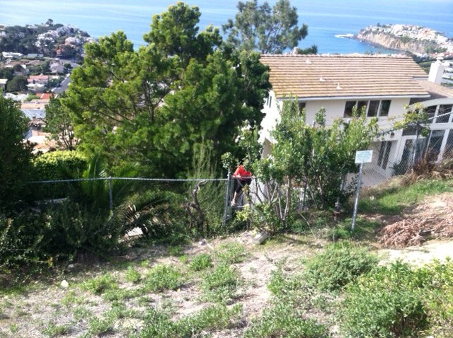
Kelsey headed down to scope the situation at what looked like the easiest way to 'hop' down. It was in between two houses that looked vacant/under construction at the time so we should go undetected.

Notice there isn't a 'no trespassing' sign in sight. Just sayin'.
Obviously she thought it looked fine because before we could go down to meet her she was up and over the fence.
I'm not sure what was funnier, the fact that none of us objected to trespassing, or that we all made it over the fence like we had been doing it for years. I need a little more back story on the shenanigans these girls got into as teenagers!
A little sliding down the front of the yard, with the aid of a few trees, a long trip down a huge flight of stairs, too bad we couldn't use the lift, and we were out of the woods. Literally.


Notice how I conveniently left myself out of any pictures taken at the scene of the crime. You never know, I might want to run for office someday.
We trekked down the hill gawking at all of the amazing houses, and keeping an eye out for any older men that might be looking for a hot young wife to take care of. OK, maybe just a younger than him, hot-ish type wife.
A few wrong little turns thanks to my Magellan like reflexes and we walked right out the front gate completely undetected.

Way to go security. You let these hoodlums roam your streets for almost 20 minutes.
Side note- they have their own fire station. I wonder how many calls they get for a suspicious smell coming from the fireplace in the bedroom of the bored housewife whose husband is away on business?
Finally on PCH, we start the 2 mile-ish trek back to where we started. Or so you would think we would just stay on the road once we finally found it. Well, if you thought that you certainly haven't been paying attention to this story.
So off the road we go, onto another path that Kim SWEARS puts us back on our original path back to our car. Which at this point in only important because that's where the food and beer are.

Wait, I see people! Oh my gosh and the trail! The actual trail we should have got on 8 or so miles ago! I though kissing it would be a bit dramatic, so here it is...with proof that we actually made it back.

We had our own 3 hour tour adventure, and despite the fact that we looked pretty haggard at the end, were a little dirty, and were completely out of water, it was a blast. And not a single scratch on any of us. Not bad for all the covert ops we had to pull.
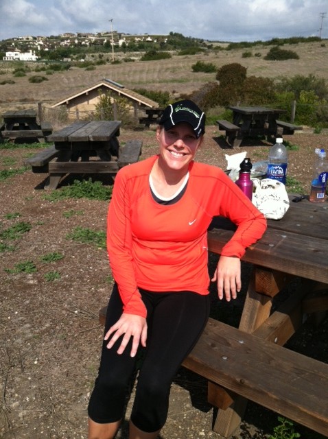
We ended with a picnic at the ranger station, and our favorite 'sodas' to cheers to an adventure we would likely not forget for a while!

That sounds like my favorite kind of run!! You need to go out trail exploring with me. Around here, it is great because you can't get REALLY lost. You'll run into a highway eventually. LOL.
ReplyDeleteSounds like a great run!!